
As the world becomes increasingly interconnected, accurate location-based information is important. From urban planning to marketing strategies and personal navigation, location-based information helps in many ways. And with that being important, Map radius tools are gaining popularity these days.
When defining specific areas on a map, map radius tools have emerged as essential aids. These tools are becoming indispensable for a wide range of applications. They allow users to create circular boundaries around a central point and gain valuable insights into distances, proximity, and coverage. But the real question is, ‘How to Use Map Radius Tools’?
Join us in this article as we explore all the bits and details about Map Radius Tools. We will also discover the best five map radius tools available. Whether you’re a business owner, a researcher, or simply curious about exploring geographic areas, make sure you stick will us till the end of this comprehensive guide.
What is a Radius Map?
A Radius Map is a visual representation of a circular area on a map. It is created by specifying an exact location and distance (the Radius). Radius Maps are handy for various purposes, be it planning activity within a specific distance, analyzing proximity, or performing market research.
Using a Radius Map, an individual or organization can seamlessly determine which areas fall within a given radius. It helps in the identification of nearby points of interest or potential targets.
Although it is possible to create a radius map with a map and pen manually, there are specialized tools that get the job done with less effort and time.
Best 5 Map Radius Tools
1. Smappen
Smappen is an online tool that offers map-based features and functionality. This Map Radius tool is known for its ability to create and customize radius maps, measure distances, and explore nearby points of interest. Smappen is designed to simplify map-based tasks and provide users with intuitive ways to interact with geographic information.
It also offers a range of additional features, including route planning, location sharing, and local search functionality. As well as, allows users to create radius maps in different ways, including Isochrone maps, Manual maps, Zip code maps, Isodistance maps, and Simple radius maps.
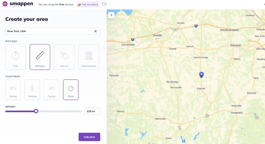
How to use Smappen, a Map Radius Tool?
Smappen allows its users to easily draw out catchment areas free of cost. The drawn areas will display and show everything within a certain distance of a given point. For using the tool,
- Start by visiting Smappen and click on Go to the Maps.
- Now under the ‘Create your area’ section in the address box, define the starting point of your zone.
- Further, select Travel-distance mode by clicking on the ruler icon. At the same time, select the As-the-crow-flies mode by clicking on the circular icon.
- Now, you can start adjusting the distance with the distance toggle. Once done, click on the calculate button and finish the task. You have now drawn your first as-the-crow-flies area and can make more such with different details.
2. CalcMaps

CalcMaps is an online platform that offers a range of useful applications for maps. CalcMaps allows users to calculate the distance between two or more points, measure areas on maps, find the elevation of paths and locations, determine the Radius of circles, and more.
The tool comes with a range of features like calculating land area, distances, and buildings’ areas, obtaining altitude, degrees, and angles, tracing contour lines, and checking the slope of the land. It allows users to share their traced data on social media platforms like Facebook and Twitter.
How to use CalcMaps, a Map Radius Tool?
- To use CalcMaps, visit the official website.
- Then click on the Radius tab from the top, navigate to the address box, type an address, and work with details like Edit circle, Draw a circle, and Radius Km.
- Now click on the Search tab next to the address box, and you are done. As you choose the option Draw a Circle, click on the Map to place the centre of the circle and drag it simultaneously to start creating the circle. CalcMaps also allow creating a circle of a fixed size. Users can also download and print the Map.
3. Maps.ie
Map.ie is known for offering various mapping services, especially a map radius tool. It has a user-friendly interface that allows users to input a specific address and define a distance around it. Like any other map radius tool, Map.ie generates a circular area on the Map while highlighting the region that falls within the specified Radius.
It is useful for planning travel routes, identifying target markets, or determining the proximity of locations. Maps.ie offers a visual representation of the radius area, making the analyzing process more accessible and more information based. It also offers other valuable features like distance measurement and route planning that add more to enhancing the mapping experience.
How to use Map.ie, a Map Radius Tool?
- Goto Map.ie portal
- You may get going immediately by searching by address or utilizing the map controls to find the desired location.
- Now click a position on the Map and drag your cursor to draw the circle. Once the circle is made, users can simply drag it to another position.
4. Mative
Maptive is a web-based mapping software with the feature of creating map radius circles. Maptive is full of features that enable users to visualize and analyze data on interactive maps. It is useful software for demographic research, market analysis, sales planning, and other tasks.
As a map radius tool, Maptive also offers functionality, including geocoding, filtering, data visualization, importing data from various file formats, and more. This user-friendly platform is accessible to both individuals and businesses alike.
How to use Maptive, a Map Radius Tool?
- Visiting maptitude. Create an account and start to create a map radius.
- Now, define a central point for creating a map with a radius circle. You can select a distance in the left toolbar or simply use a landmark or address to do so.
- Or, to add a location, go to the Map, right-click anywhere, and select Add Radius. If not, just locate Starting Location section and enter an address.
- Now enter the distance (in miles) in the Proximity Within section. Add multiple radiuses or circles on the Map and keep repeating the process.
5. Maptitude
Last but not least is Maptitude. This comprehensive mapping tool also acts as geographic analysis software. It offers a wide range of features for visualizing and analyzing spatial data. With its Map Radius Tool, Maptitude allows users to define and visualize circular areas on a map.
It is beneficial for analyzing proximity, conducting market research, or identifying locations within a specific distance. The software also offers different customization options. These options can control the appearance of the radius circle.
How to use Maptitude, a Map Radius Tool?
- Start by visiting Maptitude.
- Now, under the How to Create a Radius Map section, type an address, draw a circle, and begin exploring. With Maptitude, users can specify a central point, set the radius distance, and create a circular area on the Map.
How to create a Radius on Google Maps?
Google Maps as an application doesn’t offer radius functionality. However, there are multiple third-party programs that, by integrating with Google Maps, bring radius feature/ functionality to any usage.
Bottom Line
These were the top 5 Map Radius Tools/ Software you can use for different functionalities. The tools discussed above will help you with personal and business usage.


Very informative for newbies in map using. Thanks!